Multimedia Content
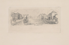
Elizabeth Street, c. 1841 - c. 1845, by Jones, Henry Gilbert (Etcher, c. 1804‑1888), courtesy of The State Library of Victoria.
Details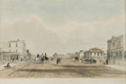
Elizabeth Street, Melbourne, 1847, by Prout, John Skinner (Artist/Lithographer, 1805-1876), courtesy of The Ian Potter Museum of Art; The University of Melbourne Art Collection. Gift of the Russell and Mab Grimwade Bequest 1973.
Details
Central Melbourne
Melbourne's central area is traditionally regarded as the 'Golden Mile' based on the grid plan survey laid down by the government surveyor Robert Hoddle in 1837. The plan provided for a township of six blocks by four, with Spencer, La Trobe, Spring and Flinders streets forming the perimeter. It shaped the pattern of early settlement, creating a strong sense of a central area. This is still Melbourne's commercial heart and the location of the city's tallest buildings. Later called the Central Business District (CBD) or, more correctly, the Central Activities District (CAD), a dynamic economy and a changing city planning environment have made it difficult to align such notions precisely with territory. City growth has created additional district centres, retailing is now more decentralised, and studies of demography have located the extended city's geographic centre further east, following a long-standing preference for growth in that direction. Central Melbourne has had its commercial and retail rivals, including Chapel and Smith streets around 1900, and many others since, but it still contributes powerfully in commercial, economic, political and social terms, and dominates the images of the city.
Central Melbourne is linked with the city's foundation and origins. Early settlement was located on the north bank of the Yarra River near a ledge of rocks (Yarra Falls) opposite the future Queen Street, above which fresh water could be obtained. Below was a basin suitable for the docking and turning of ships. From the first land sales in 1837 the area attracted investment and speculation, particularly from real estate developers. Williamstown was an early rival but it lagged behind. The grid area took on the characteristics of a town, with the original settlement at the western end proceeding east and north. The main streets were 99 feet (30 m) wide and running east-west. Parallel lanes one-third in width were to serve as rear rights-of-way to properties, most of which were two-tenths of a hectare. A 'front and backstage' character to Melbourne's street architecture resulted. With further subdivision the rights-of-way became addresses in their own right and an intricate network of lanes and alleys was created as Crown allotments were put up for resale. In the 1870s and 1880s the stigma of decaying 'back' slums was first appreciated in the central city and early social reform initiatives targeted the residents of these areas. But it was only in the post-1945 period that site consolidations resulted in the allotments being built over.
Government and law and order marked the central area early. In 1841, when market commissioners were to be elected, Melbourne was divided into four wards, with Bourke and Elizabeth streets forming the intersecting point of division: Bourke Ward to the north-west, Lonsdale to the south-west, Gipps to the north-east and La Trobe to the south-east. The Corporation's jurisdiction was the Parish of North Melbourne, from the Yarra to Victoria Parade, with an eastern boundary at Hoddle Street and the West Melbourne Swamp. Such natural features helped dictate the pattern of settlement. Public works, including drainage, roads and bridges, the development of docks and the straightening of the Yarra all consolidated Central Melbourne's position; as did public buildings such as the Old Melbourne Gaol, the State Library of Victoria, the Parliament of Victoria, the Treasury Building, the Melbourne Town Hall and the General Post Office.
Gold rush Melbourne saw expansion of settlement outside the golden mile, owing to the influx of population and restrictions imposed by the Melbourne Building Act. In 1853 George Francis Train noted the tendency of merchants like himself to 'mostly reside in the suburbs, and drive in their dog carts or come in the saddle to town'. The city was fully 9 miles (14 km) from the mouth of the Yarra River, 'and where the town first started I suppose will be its centre. But like dropping a pebble in the water, the place will continue to widen till it has swallowed up Collingwood, Richmond, St Kilda, Sandridge and all the adjoining towns.' These and other closely settled areas surrounding Central Melbourne formed the inner city, or inner Melbourne, with the more sparsely populated residential suburbs beyond.
For most of Melbourne's history, tensions have tugged inward and outward. The decentralised system of municipal government and the creation of suburbs undermined the centre, but the Melbourne City Council remained the largest and most powerful of the municipalities and a controlling influence on the Melbourne and Metropolitan Board of Works until at least 1945. Radial transport systems and the location of important government, education, commercial and cultural institutions, churches and markets all ensured a continuing central focus and specialisations not found elsewhere. The golden mile included a legal precinct and a concentration of warehouses and banking and finance in the city's western end, with retailing in the central core of Collins, Elizabeth and Bourke streets and the medical profession and related services at the east end of Collins Street. Small workshops, trades and residences were located in the back lanes and alleys and much manufacturing was undertaken here, including the furniture trade in which Chinese were employed on the northern, southern and western periphery. Ethnic enclaves have also characterised the central area, notably Chinatown and more recently the Greek precinct of Lonsdale Street. Parks and gardens on the city fringe provided a pleasing amenity for a city increasingly swollen by commuters and grown dirty with pollution.
Central Melbourne was becoming a focus for consumption and display. Urban life was to be found at its most intense and specialised in Central Melbourne, but not for everybody. Social activity was restricted for some women in the city, and shaped by ritual. By the 1880s doing the Block was an institution. Central Melbourne boasted the biggest and best markets and retail outlets, including hardware, mercery, millinery, shoe and clothing shops. Redevelopment intensified in the land boom decade. Improvements in building technology, including steel frame construction and hydraulic lifts, permitted buildings of more than three or four storeys in height and Melbourne's first generation of skyscrapers. Cable trams reinvigorated public transport and a new Princes Bridge opened up the southern suburbs. Nineteen hundred and five saw Central Melbourne's first reinforced concrete building and in 1911 the Myer Emporium inaugurated a period of central city retail dominance that lasted until the 1950s. The federal government was based in the city from 1901 to 1927, before Canberra was built. Sports grounds and venues on the city fringe drew people in and through the transport system, but there was still no city square. Restaurants and cafés and hotels provided some compensation and Young & Jackson opposite the visually striking Flinders Street Station became Melbourne's most loved 'pub'. The best bookshops were here, as was the most impressive church architecture. The centre of the entertainment precinct was Bourke Street, which was a focus for street life and prostitution. Theatre and cinemas continued to draw people until the arrival of television in the 1950s. But centrally located theatres and cinemas survived better than their suburban counterparts. Warehouses in southern King Street were converted into successful nightclubs in the 1980s following on the discotheques of an earlier generation. Tourism has bred a new generation of internationalised hotels, bars and specialty shops, dealing in fashion and costume, opals and Aboriginal art. Festivals and celebrations continue to draw on Central Melbourne's resources. Concern with urban design has meant an increasing focus on architecture and public art.
The best business addresses are in Collins Street which, following the abandonment of the city height limit in the 1960s, attracted high-rise redevelopment. The Collins Street Defence Movement mounted important campaigns and their fight strengthened the heritage conservation cause. In the 1960s the City Council promoted site consolidation and sold its public assets, the Eastern and Western markets. Town planning surveys extended the City's northern boundary to Dudley Street, the Queen Victoria Market and Victoria Street. The underground railway loop opened in 1975 and further consolidated the central area. The expansion of central business activities in the next decade pushed the boundaries of the 'central area' into East Melbourne and down St Kilda Road, where high-rise commercial and residential development transformed this boulevard. This trend to consolidation of fringe areas continued with developments across the Yarra at Southbank and west to Docklands. The opening of Federation Square has enlivened the city's southern face.
The impact of motor cars was felt as early as the 1920s when Melbourne buildings began to lose their verandahs. Parking and parking meters became an issue from the 1960s, blighting whole blocks and leading to the construction of purpose-built high-rise carparks. Pedestrianisation saw restrictions on traffic (but not trams) imposed in Bourke and Swanston streets. The Bourke Street Mall was Melbourne's first, emptying the street of cars, and concentrating pedestrians between Elizabeth and Swanston streets (in front of prominent retail outlets). It became a focus for busking and street music, and helped decay Bourke Street's eastern precinct. Paradoxically, Swanston Street Walk attracted criticism for not reinvigorating this street as quickly as hoped and was partially reopened to traffic in 1999.
While office building dominated in the 1970s and 1980s, there was a revival of alternative interests in the 1990s. Economic recession in 1992-94 saw a glut of office space, depressed rents, the vacation of older low-rise buildings and their conversion to residential use. Universities also increased their property holdings. A consequent boom in inner-city living reflected the disenchantment of post-1945 baby-boomers and their children with the suburban lifestyle. Entrepreneurs have catered to this demand, with purchasers buying units 'off the plan', notwithstanding fears of an oversupply of residential accommodation. There are problems of crime and drug use but probably to a lesser degree than in most large central city areas. Central Melbourne is more vibrant than at any time in the last 50 years.