Multimedia Content
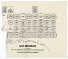
Melbourne, city allotments prior to separation, 1851, courtesy of University of Melbourne Archives; GRIMWADE, Sir Russell and Lady Grimwade Papers 1975.0089-2002.0003.
Details
Grid Plan
The plan of Central Melbourne has often been described as unimaginative, but the site was carefully chosen and the layout was more or less inevitable. The site had already been occupied by private settlers, but there were good reasons behind such settlement, which the government surveyors accepted. The wider part of the Yarra River called the Pool was delimited by a reef upstream, forming a waterfall at low tides. Fresh water, essential to the settlement, could only be obtained above the Yarra Falls. Boats could not navigate past the Falls, but below them there was ample space and even ships could moor and turn, thus making the Pool a natural landing place. Once the Pool had been chosen as the focus of settlement, the north bank was inevitably the site, because the south side of the river was low-lying swampy ground, subject to regular flooding.
Given that the site of the town was established, it was logical for government surveyors to orient the grid parallel with the river, but the topography imposed further constraints. The present Elizabeth Street is the base of a valley which ran from Batmans Hill (on the site of Spencer Street Station, but since removed), to the more loosely defined Eastern Hill. West of Batmans Hill (the present Docklands area) was again swampy ground unsuited to settlement. East from Spring Street the land was increasingly heavily timbered. The location, orientation and extent of the town were all suggested by functional considerations. Only the layout of streets and allotments remained substantially at the discretion of surveyors.
Surveyors used rectangular grids for reasons of convenience, not only to themselves but to the subsequent processes of selling and servicing the allotments. The outline of the 24 blocks bounded by Flinders, Spencer, Lonsdale and Spring streets first appears drawn tentatively over a topographical survey of the site drawn by Robert Russell. It used to be a moot point whether this outline was drawn by Russell himself or by Robert Hoddle, the more senior surveyor who replaced him, but it is now clearly established as the work of Hoddle. However it closely reflects surveying practice as developed in New South Wales under the Darling regulations of 1829, which was familiar to both men.
The Darling regulations prescribed 10 chain (200 m) square blocks each containing 20 half-acre (0.2 ha) allotments. There were no lanes, and each allotment, except those at the corners, had a single street frontage. The principal streets were 11⁄2 chains (30 m) wide and the secondary streets at right angles to them were 11⁄4 chains (25 m), a distinction soon dropped in favour of a uniform 11⁄2 chains. These were the assumptions underlying Hoddle's outline layout, and it is probable that the corners were pegged out on the ground.
When Hoddle arrived, however, he was in the company of Governor Sir Richard Bourke, who displayed a cavalier disregard for the principles of his predecessor by demanding lanes, so as to provide rear access and mews to each allotment. Bourke wanted half-chain (10 m) lanes parallel to and intermediate between the main streets, and he proposed to make up the area by narrowing the streets from 11⁄2 chains to 1 chain wide. But there was no particular need to make up this amount. It is likely that Bourke was simply trying to keep the overall dimensions unchanged, so as to avoid having the pegs taken up and the survey begun from scratch.
Hoddle was an advocate of good ventilation in towns, doubtless due to the then current miasmatic theory of disease. So, while he was opposed to lanes, he was even more opposed to narrowing the main streets, and an odd compromise was reached. The lanes were inserted, the street widths were maintained, and the overall dimensions of the survey were unaltered. Thus inevitably the allotments themselves were reduced from 1 by 5 chains (20 by 100 m), to 1 by 43⁄4 chains (20 by 95 m), and their area from half an acre each to 1 rood 36 perches (0.192 ha).
It is doubtful that Hoddle was happy with this. When Bourke returned to Sydney, and even more when he was succeeded by Gipps, Hoddle returned step by step to his principles. In the northern part of the city he widened the lanes to 1 chain, so that they became streets (a'Beckett and Jeffcott), and halved the allotment depths so that each became a quarter acre in area and fronted only one street. By 1852, in areas like Carlton and North Melbourne, Hoddle abandoned any distinction and made all the streets 11⁄2 chains, and the allotments a quarter acre. This was none other than the original Darling layout with the blocks scaled down 50% in one direction, and it became the standard quarter-acre layout, in city and country, for the next decade or two.