Multimedia Content
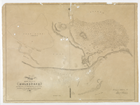
Map shewing (sic) the site of Melbourne … 1837, by Surveyed and drawn by Robert Russell. Day & Haghe, Lithographers to the Queen, courtesy of University of Melbourne Archives; GRIMWADE, Sir Russell and Lady Grimwade Papers 1975.0089-2002.0003.
Details
Maps and Mapping
In 1836 Robert Russell, appointed by Governor Richard Bourke to take charge of survey work at Port Phillip, commenced drawing a 'Map shewing the site of Melbourne', which included the Yarra River, Batmans Hill and Swamp, and some of the huts and cottages. His successor, Robert Hoddle, appointed in March 1837, superimposed the rectangular grid pattern of the city streets on Russell's map, delineating the allotments that were offered for sale in June and November 1837. Counties and parishes were also surveyed and mapped in the land surrounding the new town. Among the first parish plans drawn in the survey office under Hoddle's direction were those of Jika Jika (1838) and Werribee (1840) drawn by W.W. Darke, Bulleen (1840) and Warrandyte (1841) by T.H. Nutt, and Yan Yean (1838), Kalkallo (1839) and Prahran (1840) by Hoddle himself.
The surveying was done first by using a Gunter's chain and circumferenter, replaced later by the rather more accurate theodolite. Maps were originally drawn by hand showing rivers, coastlines, topographic features, and, as they developed, roads, railways, telegraph lines and other features. The first maps published by the Surveyor-General's Office were printed in 1853 on a lithographic press, although a few maps had been privately published as early as the 1830s and 1840s, notably J. Williamson's A Plan of Melbourne Port Phillip, which, although engraved by Clint in Sydney in 1839, can be regarded as the first printed map of Melbourne, and J.P. Fawkner's Plan of the Town of Melbourne 1841 which was printed on his newspaper press.
While mapping for land sales remained the province of the Crown Lands and Survey Department, private map-makers, some of them also working as government contractors, seized the opportunity to produce maps, particularly as guides to new immigrants and gold-rush arrivals. Thomas Ham, Cyrus Mason, J.J. Blundell, Frederick Proeschel and William Green drew maps of the city and suburbs in the 1850s. The outstanding map of this period was Melbourne and its suburbs, drawn by James Kearney, a draughtsman in the survey office, and published in 1855. These early efforts were followed, but not necessarily surpassed, by maps produced by printers, publishers or surveyors such as De Gruchy, Whiteheads, Allen & Tuxen, and directory publishers Sands & McDougall, who issued maps of the city and suburbs from the 1860s onwards. Occasionally, commissions came their way to map municipalities such as the Shire of Boroondara, the Road District of Caulfield, and J.V. Vardy's beautiful 40-page survey of the Borough of St Kilda in about 1873.
Maps and charts of Hobsons Bay, the Yarra River and the Port of Melbourne, such as H.L. Cox's British Admiralty Chart Hobson Bay and River Yarra ... (1864) and Coode's plans for the development of the port facilities in 1879, also detailed the adjacent city areas. Geological mapping began with the Geological Survey in 1859, while sewerage and drainage mapping began through the Melbourne and Metropolitan Board of Works (MMBW) in 1894. The city planning schemes of the 1920s - the 1925 Metropolitan Town Planning Commission and the 1929 Plan of General Development, forerunners of the MMBW planning schemes - used zoning maps to indicate land use.
Plans of estates being opened up to subdivision, particularly during the land boom of the 1880s and 1890s, were sometimes in the form of accurate maps, more often sketches on advertising posters. Suburban layout took place within the grid often dictated by the straight boundaries of the original subdivisions, including village reserves, usually of 320 acres (128 ha), set aside at regular intervals. More imaginative layouts were uncommon until landscape architects, such as Walter Burley Griffin and Marion Mahoney, drew elegant plans of their proposed developments in Heidelberg, Eaglemont and Croydon between about 1915 and 1923. Bird's-eye views showing individual buildings in the city and inner suburbs were issued by publishers such as De Gruchy & Leigh and McCarron, Bird & Co., sometimes as supplements to newspapers, city guides or brochures.
Australia was generally deficient in large-scale topographic mapping, and even maps for defence purposes received scant attention until World War II. The Australian Intelligence Corps (later the Royal Australian Survey Corps) was established in Melbourne in 1907 under Lieutenant-Colonel W.T. Bridges, with Lieutenant-Colonel John Monash as Officer Commanding for Victoria. Under Monash's command, about ten maps around Melbourne at a scale of 1 inch to 1 mile were compiled between 1909 and 1913, but topographic mapping at this scale was never completed, and it was superseded over a period of about 40 years by a combination of army and civilian mapping at the metric scales of 1:25 000, 1:50 000 and 1:100 000. The Melbourne sheet at this last scale was eventually produced in 1984.
Topographic and cadastral (land ownership) mapping continued to be the responsibility of the Lands Department (later Land Victoria). Its base maps have been used by a range of other service providers such as electricity, gas, sewerage and drainage authorities. In collaboration with the MMBW (now Melbourne Water) and local government, it has produced base maps for the outer metropolitan area, Mornington Peninsula and Dandenong Ranges. The MMBW also produced maps at scales of 1:2500, 1:5000 and 1:10 000 from the 1970s to the 1990s, covering an ever-widening area as the metropolitan boundary was extended. Keeping pace with this suburban development, road maps and street directories grew in coverage from the cycling guides put out by Broadbents in the 1890s and the pocket-size books of Moultons/Morgans in about 1910, to the large volumes of Melways and UBD which are a part of life for most Melburnians. In the 21st century it is likely that their place will be taken, at least partially, by in-car and home computer navigation systems, and that GPS (Global Positioning Systems) will be a major means of direction-plotting and mapping.
- References
- Leeuwenburg, Jeff, The making of Melbourne in maps, Longman Cheshire, Melbourne, 1987. Details