Multimedia Content
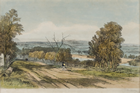
Vale of Heidelberg near Melbourne, 1847, by Prout, John Skinner (Artist/Lithographer, 1805-1876), courtesy of The Ian Potter Museum of Art; The University of Melbourne Art Collection. Gift of the Russell and Mab Grimwade Bequest 1973.
Details
Heidelberg
(3084, 12 km NE, Banyule City)
Heidelberg's 19th-century history is dominated by three factors: the beauty of its well-watered and undulating land along the Yarra Valley; the initial fertility of the land which made it ideal for grazing and farming; and problems of communication with Melbourne.
In September 1838 these first two attractions caused the district to be one of the first in the Melbourne region to be subdivided, and led to it becoming an area of prestige properties for some of the colony's prominent citizens. The name Heidelberg is attributable to one of the early land agents who promoted the district's supposed resemblance to its German namesake. To improve access to Melbourne, in 1841 a group of this 'Heidelberg aristocracy' formed the Heidelberg Road Trust, the first local government body in what became Victoria. The Trust soon collapsed but was later revived and in 1847 it began collecting tolls on the macadamised Heidelberg Road. In the meantime, the Heidelberg (then Warringal) township, nestled in the valley with its pretty buildings such as St John's Anglican Church and the Old England Hotel, was often likened to an English village.
The 1840s depression ruined several of Heidelberg's gentlemen, and by the late 1840s the region had become largely an agricultural district with many absentee landowners. The 1850s gold discoveries brought a brief agricultural boom as the fertile Yarra flood plains helped to supply the expanding market for food produce. But in the 1860s and 1870s increasingly frequent floods and exhaustion of the land brought agricultural decline, a move to dairying, and a social somnolence in this quiet rural beauty spot.
The 1880s land boom resulted in a limited spurt of subdivision and construction in and around the village. In 1891 there were only 713 people in 134 inhabited dwellings. A more general encroachment of suburbia was held back by the absence of good communication with Melbourne, especially a railway. This was compounded by the physical and psychological barrier created by the need to pass through the Collingwood slums. When a railway line finally opened in May 1888, it took such a circuitous route across the northern suburbs that the excessive fares and travel time discouraged commuting.
Nevertheless, it was this period which saw the name of Heidelberg impose itself on Australian history. The aesthetic attractions of the valley and the availability of a vacant mansion on the Eaglemont hill brought the group of artists now remembered as the Heidelberg School to the district in the late 1880s.
At the start of the 20th century Heidelberg was relatively undeveloped with suburban housing limited to a narrow band along the Yarra Valley. The opening of a more direct railway link to Melbourne in 1901 began four decades of slow and relatively affluent suburban sprawl. This occurred principally on the fringe of the township and southward towards Eaglemont and East Ivanhoe, in the attractive undulating areas within easy reach of the Yarra and the railway.
The end of World War II ushered in a period of extraordinary growth as a growing population and increased motor car ownership accelerated suburbanisation. Heidelberg expanded onto the flatter plains to the north-west of the township into West Heidelberg. Much of this area was of a different socio-economic character from the longer settled parts of the suburb with large areas developed as Victorian Housing Commission estates. In the midst of these, the 1956 Olympic Village was built.
The 1960s and 1970s saw most of the rest of the suburb subdivided. Lower socio-economic housing and industrial estates continued to spread across West Heidelberg and Heidelberg Heights. North along the Yarra Valley there were more middle-class developments in the new suburbs of Rosanna, Banyule, Viewbank and Yallambie. Heidelberg's commercial district is centred around Burgundy Street and the Warringal Shopping Centre, and the suburb includes the Warringal Cemetery and the Austin and Repatriation Medical Centre.
- References
- Garden, Donald S., Heidelberg: The land and its people 1838-1900, Melbourne University Press, Melbourne, 1972. Details