Multimedia Content
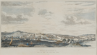
Melbourne from the South Side of the Yarra Yarra, 1839, by Carmichael, John (Engraver, c. 1811-1857); Adamson, James Hazell (Artist, 1829-1902); Clint, Raphael (Publisher, 1797-1849), courtesy of The Ian Potter Museum of Art; The University of Melbourne Art Collection. Gift of the Russell and Mab Grimwade Bequest 1973.
Details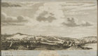
Melbourne from the South Side of the Yarra Yarra, 1840s, by Carmichael, John (Engraver, c. 1811-1857); Adamson, James Hazell (Artist, 1829-1902); Clint, Raphael (Publisher, 1797-1849), courtesy of The Ian Potter Museum of Art; The University of Melbourne Art Collection. Gift of the Russell and Mab Grimwade Bequest 1973.
Details
Yarra River
Melbourne and its river have had an uneasy relationship, marred by the exploitative demands of industry, compromised by the irresponsible excesses of its citizens, tamed by the imperatives of flood mitigation. The brown murkiness of the 'upside down' river has long been caricatured. But however much the Yarra's image is denigrated, often in derisory comparison with the natural beauty of Sydney's harbour setting, the Yarra is as integral a part of Melbourne's geography and as intimate a part of its psyche as the Thames is to London or the Seine to Paris.
Melbourne's location was determined by the existence and the characteristics of a modest river now known as the Yarra. The availability of fresh water above rocky falls at a site on the river 10 km from its mouth persuaded John Batman in 1835 that 'this will be the place for a village'. Any commercial settlement in the early 19th century needed fresh water to drink and salt water upon which to float its trading ships, so from the beginning European eyes looked upon the Yarra to assess its utility. Robert Hoddle soon pegged out his city grid to align with the course of this useful river.
Europeans had first discovered the river some years earlier. In January 1803 the Cumberland brought a naval survey party commissioned by Governor King to Port Phillip Bay. A journal kept by James Flemming notes that the party reached the Yarra River on 2 February and followed its course as far as Dights Falls at Studley Park. A diary entry on 26 February 1803 contained a simple but prophetic observation: 'The most eligible place for a settlement that I have seen is on the Freshwater River'.
In October of the same year Lieutenant-Governor David Collins arrived in Port Phillip on the Calcutta and established a short-lived convict settlement at the site of present-day Sorrento. First Lieutenant James Tuckey carried out a general survey of the Bay. He observed a break in the land at the northern extremity having 'the appearance of a river', but was prevented by bad weather from exploring it in more detail.
John Batman and his party in the Rebecca reached the mouth of the Yarra on 2 June 1835, initially exploring the saltwater (Maribyrnong River) branch. Though it is unclear whether Batman himself took part in the short trip up the Yarra, his diary records on 8 June 1835: 'The Boat went up the large River I have spoken of which comes from the East, and I am glad to state about six miles up found the River all good water, and very deep - this will be the place for a Village. The Natives on shore.' To Governor Bourke, who visited the settlement in March 1837, the river was 'perhaps the finest river I have seen in New South Wales ... The Yarra abounds in fine fish and the water is of very good quality'.
People moving inland from the infant settlement and south from Sydney soon mapped out the upper course of the Yarra and appraised the usefulness of the land and timber alongside its banks, however it was not until the first decade of the 20th century that the headwaters of the river were finally identified through the efforts of the Field Naturalists Club of Victoria.
Flemming had variously referred to the river as the Great River, the branch, or the Freshwater River (as opposed to the Saltwater or Maribyrnong). While John Batman's map called it 'Batman's River', its eventual naming is attributed to J.H. Wedge, surveyor for Batman's Port Phillip Association. Wedge's notebook recorded the name 'Yarrow Yarrow', a rendering of 'Yarra Yarra', though he later conceded that he had confused the Aboriginal term for rapids or waterfalls with the name of the river itself. The Aboriginal peoples knew the river as Birrarung.
From its junction with the Saltwater River, the Yarra was choked with trunks and branches, making navigation difficult, but its course was gradually charted and cleared. The natural quay between Queen and Spencer streets allowed ships to tie up right on the city's doorstep. Punts and ferries and then bridges spanned the river allowing the free movement of people and commerce as Melbourne spread. Upstream of the growing city water-using industries - fellmongers, wool-washers, tanneries and other noxious trades - clustered along the riverbanks. The river was not only a source of water for processing but also a convenient place to dispose of waste, and an accumulating cargo of rotting animal parts, household rubbish and other pollutants flowed with the stream towards Hobsons Bay. People living in the City of Melbourne were not pleased as they drew their drinking water from pumps between Queen and Russell streets and risked the ever-present threat of waterborne diseases until the Yan Yean scheme rescued them in 1857. Nevertheless, people bathed in the river, fished in it and rowed on it for recreation. These conflicting uses of the river degraded it rapidly. Legislation was introduced to combat pollution but it was not effectively enforced. By the 1890s a Scottish traveller claimed it was 'the filthiest piece of water I ever had the misfortune to be afloat on'.
By the end of the 19th century the worst of the abuse was over. Most of the noxious industries had migrated to the Maribyrnong at Footscray and Flemington. After the belated construction of an underground sewerage system in the 1890s, the city's body wastes went to the sewerage farm at Werribee to be treated, instead of filtering into the Yarra and its tributaries. Much industrial waste also went into the sewers.
The Yarra did not always submit passively to abuse. Every few decades it burst its banks and took furious retribution on those who had built on its floodplain. In 1803 Flemming had noted flood marks on trees along the river which were 20 feet (6 m) above the ground. European settlers experienced their first major inundation on Christmas Day 1839 and from then on a fear of floods was a continuing anxiety. A great flood in December 1863 stretched from the Customs House to present-day Toorak Road.
English engineer Sir John Coode's 1879 report to the Melbourne Harbor Trust was a catalyst for major flood mitigation schemes and harbour extensions. In addition to taming the river by dredging and the removal of reefs he recommended the cutting of a channel to shorten the river's erratic course at Fishermans Bend. Digging started in 1880 as unemployed relief work with water let into the Fishermans Bend Cut in 1886. The cut was officially named Coode Canal in 1899, with the island it created known as Coode Island. Coode also recommended the construction of Victoria Dock. Its completion in 1892 was the first stage in the migration of the wharves and docks downstream towards Hobsons Bay, a process that has continued to the present day.
After another major flood in 1891, a Yarra Floods Board recommended that the river be widened and deepened along its lower reaches. The Yarra Improvement Act 1896 enabled the Board of Land and Works to undertake major realignments between Princes Bridge and Church Street. Between 1897 and 1901 the Botanic Gardens Cut straightened the Yarra by removing a series of billabongs which had banked up flood waters. The new route of the river took it beneath the newly built Morell Bridge (1899), one of Australia's first reinforced concrete bridges.
The Metropolitan Drainage and Rivers Act 1923 gave the Melbourne and Metropolitan Board of Works (MMBW) control and management of all streams in metropolitan area, including the Yarra upstream of the Melbourne Harbor Trust area. In 1928-29, the MMBW constructed the quarry cut through the Richmond Quarries as a flood control measure. It severed from the north bank an island initially known as Como Island, but renamed Herring Island in 1952. None of these activities could prevent the massive inundation of 1934, the worst of the 20th-century floods. The Board's desnagging and tree-clearing campaign, while improving boating access and helping flood control, generated considerable hostility from residents of outer suburbs bordering the Yarra who enjoyed the scenic qualities of the meandering sluggish willow-lined river. They argued that the Board's activities were causing rapid bank erosion.
A division had opened up between those valuing the picturesque and those wanting a safe navigable river on which to travel. The first discussions of Yarra improvements came out of a broader concern with civic improvement and public health in the last decade of the 19th century. There was a convenient marriage of beauty and utility in that practical improvements that would make the river more useful or less damaging were seen also to enhance its beauty and its recreational potential. The Metropolitan Town Planning Commission report of 1929 offered a new vision of how Melbourne might use the Yarra and its tributaries, with recreation as its focus. It recommended that a system of radial parks should be created with the creeks as their spines. These would compensate Melburnians for the parklands which had not been reserved when the suburbs had pushed outwards during the previous two decades. The depression intervened, but part of the Yarra Boulevard - which was envisaged as a recreational driveway after US exemplars - was built with sustenance money and stretches of the banks of the Yarra and the Maribyrnong were lined with bluestone blocks to prevent erosion. By the late 1930s municipal cooperation led to a series of Yarra Improvement Conferences which revived many dreams and schemes for the river, including a lock at Dights Falls, the screening of factories which backed onto the river with tree plantings, completion of the Yarra Boulevard and the creation of parks. Little was done before the war intervened.
During the 1930s it was thought that the arrival of the motor car would open up wider recreational horizons to the people of Melbourne and they would turn away from the river as a place to play. Yet they still came to the annual Henley-on-Yarra regattas in their thousands and continued to take their ease on or beside the river in traditional ways. From 1854 the Upper Yarra Steam Gondola Co. had taken pleasure-seekers to entertainments at Cremorne Gardens at Richmond. Rowing regattas had become popular at least from the 1860s, and boathouses at Studley Park (1863) and Fairfield (1908) remain popular refreshment and recreation spots.
Melbourne's headlong growth during the 1950s and 1960s posed new threats to the river in the form of pollution and freeways. Older pollutants were joined by a new generation of persistent chemicals that began to find their way along broken sewers and drains into the river. The Board of Works seemed ineffective in stopping septic tanks, increasingly prevalent in the outer suburbs, from allowing human sewage back into the river after an absence of over half a century.
Like the park planners in the 1920s, postwar traffic planners looked to the cheap land along the radial creek system for their planned freeways. There was little concern when the first stage of the South Eastern (Monash) Freeway skirted an unattractive industrial zone on the river's northern bank, but as it moved further east it took up playing fields of prestigious independent schools and overshadowed more attractive stretches of the river. The proposed Eastern Freeway was even worse, carving through the Yarra Bend National Park. Battles over road routes would continue for more than 15 years. As in the USA, the parkways had been the precursors of the freeways, but the freeways being built in the 1970s and 1980s cut people off from the river rather than let them enjoy its beauty as they passed through or above it at 100 km per hour.
By this time, port activities on the river had moved decisively downstream. The Spencer Street bridge (1930) cut off the old city wharves from seagoing ships as it was too low for them to sail beneath, a method of exclusion which was repeated with the Charles Grimes Bridge (1975) and the Bolte Bridge (1999) which blocked the entrance to Victoria Dock to shipping of any size. Appleton Dock, under construction for more than 20 years, finally opened in 1956, while Swanson Dock, Melbourne's first dock designed specifically for containerised cargoes, opened in 1969.
Despite the early impact of urbanisation on its natural qualities, the Yarra continued to be celebrated as a highlight of Melbourne's rural and botanical attractions. The same river which gave life to the city that spanned it, took life away from the drowned that were dragged from its waters and laid out at the City Morgue on its bank. Such was the topography and social geography of Melbourne that as early as the 1880s the river symbolised - as it does to this day - a class divide between middle-class (south-eastern) and working-class (northern and western) suburbs, the contrast at its sharpest where Kew's mansions looked over the river to the workers' cottages of Abbotsford.
Both the port river at the city's commercial heart, and the idyllic corridor along the Yarra Valley provided inspiration to artists of the Heidelberg School in the late 19th century. Visual artists have long set the city's scene to the Yarra's mood, as in the stereotypical 1950s skyline image of the garden city on the river. This image was marred in recent decades by the Flinders Street Gas and Fuel Buildings, until they were demolished in 1997.
The city planning blueprint for Melbourne's future growth, released in 1954, had virtually ignored the Yarra, but Melburnians did not. In 1958 a proposal to subdivide the old Banyule Estate into residential blocks attracted considerable opposition. A Save the Yarra Valley League fought a shrewd campaign. Other grassroots campaigns followed. By the 1970s planning policies came to recognise that the Yarra River and its environs should be primarily classified as recreational and nature reserves. The MMBW assumed control of the Yarra above Princes Bridge in 1984. Yarra Bend Park, Warrandyte State Park, and Yarra Valley Metropolitan Park, embracing more than 2000 ha of open space and over 60 km of the river, were created. They reflect changed attitudes to the environment and a belated realisation of the vision expressed in the 1929 town plan.
Press campaigns from the 1920s had also helped shape public perceptions. The sombre and unattractive lower reaches were increasingly imagined as a picturesque waterway and potential fairyland at Melbourne's feet. From the 1940s to the 1970s the Yarra was depicted as a 'two-faced' river: Mother Stream of the Village of Melbourne, but also Melbourne's biggest drain. From the 1970s the new language of environmental concern was used increasingly in connection with the river, and investigative journalism focused attention on the river's problems. In 1971 the Herald launched its 'Battle for the River' series and in 1980 the Age began the 'Give the Yarra a Go' campaign. Targeting the city reach of the river, the Age argued that it should be converted into a recreational buffer to lend scale and softness to a fast growing and bustling urban centre.
Enabling legislation, a planning scheme and some public money saw the beginnings of a clean-up, but it was private finance which would re-create this part of the riverside landscape. The 1990s saw a rush to the stretch of the river immediately south of the city business district, that had become increasingly deserted and run down as the docks migrated downstream. Developments at Southbank, Crown Entertainment Complex, the Melbourne Exhibition Centre, Docklands and Federation Square re-focused recreational as well as commercial activity onto the stretch of the river which originally gave birth to Melbourne.
A persistent theme of river reformers had been rus in urbe. They hoped the sylvan river would refresh jaded city dwellers and workers. At the beginning of the 21st century, however, the Yarra in Central Melbourne is a denatured stream, a regulated canal flowing between geometric banks. Its contemporary visitors seek essentially urban forms of stimulation, the river no more than a backdrop to other activities rather than the reason for their coming. In this sense, the Yarra in Central Melbourne has become popular not because it has greened the city, but because the city has commercialised it by incorporating it into the urban landscape.
- References
- Lacey, Geoff, Still glides the stream: The natural history of the Yarra from Heidelberg to Yarra Bend, Australian Scholarly Publishing, Melbourne, 2004. Details