Multimedia Content
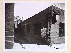
Griffin Lane - west side, corner with Little Lonsdale Street, 1950, by Australia Dept. of Housing and Construction Victoria/Tasmania Region, courtesy of State Library of Victoria.
Details

Griffin Lane
Griffin Lane is located between Exhibition and Spring streets, extending to the south from Little Lonsdale Street. Formerly known as Brophy Alley, Griffin Lane was named prior to 1856 after hay and corn merchant William Griffin.
Several of Melbourne's laneways had a reputation for attracting people of undesirable character. Often poorly lighted and located near to popular drinking venues, there were frequently reports of robberies, assaults, and indecent behaviour such as violence, larrikinism and vagrancy. One such report was made on 11 November 1862 by Robert Kay of Griffin Lane. He complained that a certain Mrs Cleary frequently used 'obscene language' when drunk. Even more cause for complaint was an incident in which Kay was witness to Cleary and her sister-in-law 'exposing her person in the open rightaway'. Griffin Alley was also the location of the Governor Bourke Hotel in 1860.
- References
- 'Central Melbourne - Lanes F-H', in Amendment C105 - CBD Laneways Review, City of Melbourne, 2007, http://www.melbourne.vic.gov.au/info.cfm?top=195&pg=3065&bp=1902&coll=8. Details
- Bate, Weston, Essential but unplanned: The story of Melbourne's lanes, State Library of Victoria and the City of Melbourne, Melbourne, 1994. Details