Multimedia Content
Tavistock Place
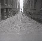
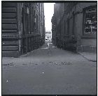
Located between William and Queen streets, Tavistock Place extends from Flinders Lane to Flinders Street. It was formed and named pre-1856, possibly after London's Tavistock Street. At the north-west corner of the lane is Tavistock House, built in 1850 as the Ship Inn from architect Samuel Marlow's design. Tavistock House stands as one of Victoria's earliest surviving hotel structures and is among a small group of pre-gold rush buildings in Melbourne. From the 1860s to 1890s, Tavistock Place was dominated by the offices of mining companies. In 1935, the Excell Press printers were located in the lane, as were two manufacturing agents-an outerwear clothing store and the Dura-Tex Hosiery Company.
- References
- Sands & McDougall’s commercial and general Melbourne directory, Sands & McDougall, Melbourne, 1935. Details
- 'Tavistock House, 383 - 387 Flinders Lane, Melbourne: VHR No H0787 File No 603040', in Victorian Heritage Register On-Line, 2000, http://www.doi.vic.gov.au/doi/hvolr.nsf. Details
- 'Central Melbourne: Lanes S-Z', in Amendment C105 - CBD Laneways Review, City of Melbourne, 2007, http://www.melbourne.vic.gov.au/info.cfm?top=195&pg=3065&bp=1902&coll=8. Details
- Bate, Weston, Essential but unplanned: The story of Melbourne's lanes, State Library of Victoria and the City of Melbourne, Melbourne, 1994. Details


