Multimedia Content
image
- Title
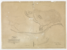
- Map shewing (sic) the site of Melbourne … 1837
- Description
Map shewing (sic) the site of Melbourne and the position of the Huts & Buildings previous to the foundation of the Township by Sir Richard Bourke, in 1837
- Date
- 1837
- Creator
- Surveyed and drawn by Robert Russell. Day & Haghe, Lithographers to the Queen
- Control
- Accession: 1990.0098 Series 19/12
- Source
- University of Melbourne Archives; GRIMWADE, Sir Russell and Lady Grimwade Papers 1975.0089-2002.0003
Related Entries
Concepts
Entries
People
Created: 20 November 2014, Last modified: 24 November 2014

